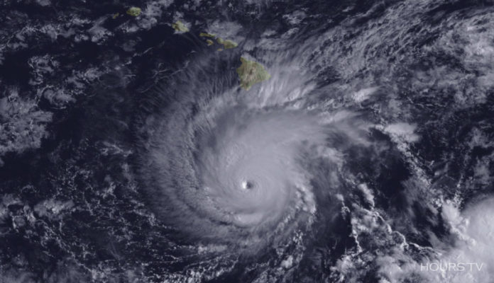
Hurricane Lane, is a powerful tropical cyclone(rapidly rotating storm system) currently approaching the Hawaiian Islands. Lane is the strongest hurricane in the Central Pacific since Hurricane Ioke in 2006, which proved to be the most intense hurricane ever recorded in Central Pacific; and the first Category 5 Pacific Hurricane since Patricia in 2015 which was the second-most intense tropical cyclone on record worldwide.
Hurricane Lane and Hawai
Hawaii, The Big Island, is hit with gales, down pouring and torrential rain as Hurricane Lane approaches the US state, causing flash flooding and landslides.
Schools and offices are closed as residents took shelter from the storm.
Hawaii Governor David Ige advised inhabitants to collect and preserve adequate supplies of water, food and medicines as advance necessary measures and to avoid driving vehicles if possible.
The Federal Emergency Management Agency (FEMA) has a number of barges with food, water, and supplies transported into the region ahead of Hurricane Hector, which passed along the edges of the island more than a week ago.
The U.S. Navy was moving submarines and ships out of Hawaii. All vessels that are currently not undergoing any kind of maintenance work are being deployed for help in response to Hurricane Lane, if needed.
Weather Reports on Hurricane Lane:
Forecasters say Lane’s present path has the storm coming “perilously close” to the main Hawaiian Islands. In addition to heavy rainstorm, the Hurricane Lane is shoving up wave heights and could mean powerful winds. Weather Forecasters also informed that Lane’s eye spanned over a buoy about 250 miles southwest of Hawai on Thursday morning, and a peak wind speed of 107 mph was registered.
The National Weather Service (NWS) alerted that some areas could see up to 30 inches high rainwater before the hurricane passes. Sections of rain extended 350 miles from the hurricane’s eye. Hurricane-force winds expand 35 miles from the center of the hurricane, while tropical-storm-force winds lengthen outward up to 140 miles.
National Aeronautics and Space Administration and National Oceanic and Atmospheric Administration shared an eye-shot of Hurricane Lane from space displaying the huge swirling storm clouds closing in on Hawaii. The picture, taken by the GOES-15 satellite Wednesday, divulging the well-developed eye of the storm located about 300 miles south of The Big Island.
President Trump issued an emergency and disaster declaration for Hawaii on Wednesday, permitting the Department of Homeland Security and FEMA, to coordinate disaster-relief efforts with the state.
Read Also:
Kerala Floods: Displace More Than 800,000 And Leave Almost 370 Dead


